COPENHAGEN

click on your destination
AMAGER BAKKE
The Amager Bakke is better known as the Copenhill plant. It is a type of incinerator in which the heat developed during the combustion of waste is recovered to produce steam, which is used for direct production of electricity or as a heat carrier. BIG's project for the Amager Resource Center in Copenhagen is a redefinition of the engineering and architectural concept of producing energy, integrating it with the simplest human interests. In Denmark, a region known for being typically "flat", not exceeding 172 meters above sea level, Bjarke Ingels' studio built a giant waste-to-energy plant whose roof is a single, wide surface that bends 180 degrees on itself. A structure that makes it possible to combine modern and functional architecture with energy production. Could it be considered a resilient building? Does this structure really sum up what adaptation to external phenomena should aim at? We are unable to answer these questions, because of a lack of data and scientific references that allow us to effectively assess the actual costs and benefits of this structure. Building imposing structures with a high political-mediatic impact ,is not necessarily part of a resilient process, but is definitely a symbol for the world-to-see that complements a
series of local policies. But it is important to understand that such structures need to work as part as a system and not as stand-alone. In this regard, the EPA (Environmental Protection) an agency of the Federal Government of the United States of America, in charge of environmental and human health protection, has developed a hierarchical pyramid of evaluation of non-hazardous waste disposal procedures recognizing that a single methodological approach to disposal is not valid for all circumstances.
This hierarchy follows the logic of prioritizing the reduction of material contributing to waste production, re-using and recycling.
Energy recovery with waste-to-energy plants is part of this pyramid, positioned above waste treatment and landfill (at the base of the pyramid!). This is because the confined and controlled combustion of waste decreases the volume of solid waste to be buried in landfill sites and also makes it possible to recover energy from its combustion, becoming, according to the EPA, a renewable energy source that reduces carbon emissions by reducing both the demand for energy from fossil fuels and methane emissions from landfills.

.jpg)
Artistic concept by BIG architects
The integrated sky plant as rendered by BIG architects

The plant height compared to Copenhagen's main monuments by BIG Architects
PHOTO GALLERY
TÅSINGE PLADS
Inaugurated in December 2014, the Tåsinge-Plads (better known as Water Park) is the pilot project for the climate adaptive urban regeneration program, planned for the whole of Saint Kjeld's Kvarter. The key concept is that the square is designed aa basin for water storage in case of heavy raining or flooding. The entire masterplan of the district, designed by the Tredje Natur studio, is imagined with adaptation in mind, is foreseen the construction of green areas (green corridors, trees, rain-gardens, etc.) for a total of 50,000 m², in contrast with the 270,000 m² currently occupied by roads.
The aim of the project being reducing asphalt covered areas by 20% in favor of permeable areas with greater water infiltration capacity during extreme rain events. The implementation of the masterplan will lead to several minor projects, which will be completed in the future. Saint Kjeld's Kvarter is considered to date, the world's first resilient urban area, as well as being the the project that started the season of climate adaptation in the Danish capital.
Tåsinge Plads was designed to slow down, channel and reuse water in different ways. Lets briefly analyze how the system works. The paving is inclined in such a way that it helps collect the runoff water from the surrounding streets towards the central area, avoiding flooding downstream of the square. The water is also redirected to permeable flowerbeds, able to absorb excess precipitation thanks to non-blocking kerbs and capable to use rainwater directly to water the vegetation. In addition, several umbrella-shaped installations have been positioned to collect rainwater and temporarily store it in basins below the pavement. Through hand pumps, designed for the amusement of children, the water from these tanks can be pumped into the surrounding flowerbeds. With these simple interventions, the square plays not only a role as a lamination basin, although for modest amounts of water, but also provide a green self-sufficient area integrated into the rainwater collection systems and a playground and social space for all ages.
Masterplan of the new square project by Tredje Natur studio

PHOTO GALLERY
SUPERKILEN PARK
One of the most significant examples of intervention on public spaces is the Superkilen park project located in Nørrebro Kvarter's. Since the 1980s, Nørrebro has been the scene of great social unrest, which has contributed in part to its urban stigmatization and for which is still remembered with emphasis by its citizens. Today, the greatest challenges it faces are linked to the cultural diversity of its 70,000 inhabitants, who come from more than 60 different countries. The project for a new park, which began in 2008, is not just part of the vision to foster climate adaptation but is specifically oriented toward social integration. In fact, it serves as an inspiration to other multiethnic realities trying to celebrate the cultural diversity in difficult neighborhoods. The work, inaugurated in June 2012, was entrusted to the artistic group Superflex with the collaboration of Bjarke Ingels Group and Topotek1, a German landscape architecture company. Superkilen was initially conceived as a world exhibition of street furniture, play and sports facilities, art installations and plant species from all over the world. Many of these components were suggested by the residents themselves, who took part in various stages of the design process.
The participation proved to be an expression of cohesion: the cultural diversity of the neighborhood was interpreted as a quality to be preserved and celebrated. The park offers ethnic, cultural and linguistic references in which both locals and foreign residents could recognize themselves and, at the same time, learn to know and appreciate other cultures, constituting a matrix for deep urban regeneration.
The park is divided into three main sections that are clearly recognizable because of three different flooring colors. The sections cores are linearly connected by a long cycling and pedestrian path. The "Red Square" is distinguished by the presence of artistic installations and cultural references. The "Black Market" is a smaller part covered with black asphalt and sinuous white lines, among which stands out a large Moroccan fountain, which becomes a meeting point and distinctive centrality of the area. The "Green Park" is the largest part of the park, it is almost entirely occupied by greenery, as well as dotted with elements of street furniture (benches, hammocks, picnic tables, swings) from various parts of the world.
Superkilen plan by BIG, Topotek1 and Superflex


Red square photo by Iwan Baan
Black Market photo by Iwan Baan
PHOTO GALLERY
SCANDIAGADE
The Scandiagade route is a project for resilient a public space in the Sydhavnen district that differs a lot from the previous ones. It was entrusted by the city of Copenhagen to the design studio Landskab 1:1 and completed in 2019. The main function of this space to provide for containment, storage and drainage of water in case of extreme events while offering a linear park with walkable and cyclable path for residents.While crossing Scandiagade you can perceive the engineering attention that has been dedicated to this project. Unlike the visual and artistic impact of Superkilen, here what stands out is the skillful structural composition combining multiple functions (water storage, accessibility) while trying to harmoniously insert the path in the pre-existing urban context through different techniques like specific selection of materials.
The central part of the path, once home to centuries old trees has been transformed into an innovative urban space with eight basins that can hold 1,500 m3 of water. In case of rainfall, these basins ensure that the sewers will not overflow, delaying the infiltration process.
In the absence of rain they are used as areas for playing, training, resting or socializing. The basins are connected by a wooden walkway with neon yellow sides, a characteristic feature of the park. The design process of the area involved the residents, who had a say in the design of the basins: the result, in fact, shows eight very different areas mirroring the desires of different city blocks. In addition, Landskab 1:1 wanted to create an area with a high degree of biodiversity, so that the park is home to 126 different tree species.
render by Landskab 1:1 studio
Plan and side view of the project by Landskab 1:1 studio


render by Landskab 1:1 studio
PHOTO GALLERY
SLUSEHOLMEN
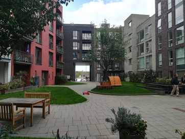
As far as residential neighborhoods are concerned, a good example of a resilient approach applied to new development is certainly Sluseholmen: an artificial peninsula located near the southern port of Copenhagen. This area has undergone a massive redevelopment since the early ‘00s, which has transformed it into a predominantly residential district, known for its canals and maritime atmosphere. The first phase of construction began in 2004 and was completed in 2008. The public space is defined by the shape and morphology of the residences, common areas are often located in open courtyards and they are maintained and cared for as if they were private property. These spaces host installations, games for children, barbecues and greenhouses. They constitute well thought places of aggregation for local to be enjoyed and discovered. This district represents an example of resilient design firstly because is a development born from the ashes of an industrial past.
As a matter of fact, the city has been able to change not only the area’s land use but also its overall vocation and perception in an effective way. Secondly, It’s a resilient space because the whole complex is designed in a systemic way where natural resources, like water, characterize the space. The construction of an artificial "Community of canals", inspired by the Netherlands, becomes not only a key element for excess water drainage, but also a qualifying and identifying piece of the district’s “image” or “representation”.
Moreover, the constant increase of population of Copenhagen’s metropolitan area has led to further expansion of this area to artificial structures beyond the coast. The project has been entrusted to the Gröning Arkitekter studio, which is currently working to complete the expansion of the district and provide it with all the necessary basic services to make it attractive: a new health centre, a school and the extension of the metro line are planned.
Masterplan Sydhavnen 2000 by Soeters Van Eldonk architecten


Masterplan Sluseholmen by Soeters Van Eldonk architecten

Model of Sydhavnen 2000 by Soeters Van Eldonk architecten
PHOTO GALLERY
SANKT KJELDS PL.
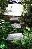
The area around Sankt Kjends plads is located in the densely populated Østerbro district. It has some of the best examples of widespread hydraulic and naturalistic engineering interventions to augment urban resilience relative to flooding. Like the transformation of what used to be a simple street roundabout to a lush micro-ecosystem that strike the observer with its wild appearance, odd sight in the heart of the crowded central district. The space is hollowed out in the center allowing for a slow and natural water drainage. In addition, the chosen tree species contribute to the purification of both the atmosphere and the water resource itself. A path through the trees and benches allow the inhabitants to enjoy this unusual urban space, which only a few years ago was just a bare road junction.
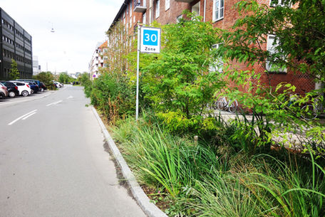
In the same area we can find the transformation of the sidewalks of Bryggervangen Street. They became, through simple measures, flourishing green corridors. Fed by water from the building’s gutters and occasionally by water containers for the plants that require more water, the spaces next to the sidewalks have been quickly colonized by many different botanical and entomological species, indispensable for managing the ecosystem equilibrium. Instead of channeling water from the roofs of neighboring buildings into the sewage system, the gutters channel it, passing under the pavement, to the flowerbeds. The gravely soil in the vicinity of the drains ensures a lowering in the kinetic energy of the water, guaranteeing greater longevity to what are apparently simple flowerbeds but conceal a functional water drainage system.


